
 September again, so off for my annual visit to the York Book Fair last weekend. For once I’ll gloss over the startling inadequacies of both my riverside hotel and the Italian restaurant nearby, because it remained a thoroughly enjoyable couple of days nonetheless. Lots of book-chat (and a modicum of gossip) with friends old and new, old and young – and an excellent haul at the fair itself, in fact my best haul at York in some years.
Lots of purchases I could very easily write about, but my favourite is this attractive Victorian cloth folder simply titled “Diagrams of Geology, History, and Physical Geography”. Inside are eighteen attractive diagrams on card, all published by James Reynolds (1817-1876) of 174 Strand in London, with two (“Waterfalls” and “Eclipses”) bearing the additional imprints of other contemporary London publishers. Most of the diagrams also feature explanatory notes. Not all are dated, but those which are range in date from 1846 to 1850, and the topics covered veer off into architecture, astronomy, ethnography, and the prehistoric, as well as those promised on the cover.
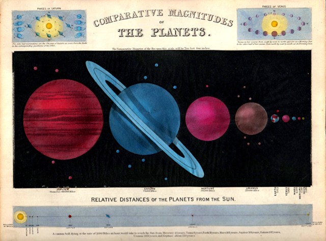
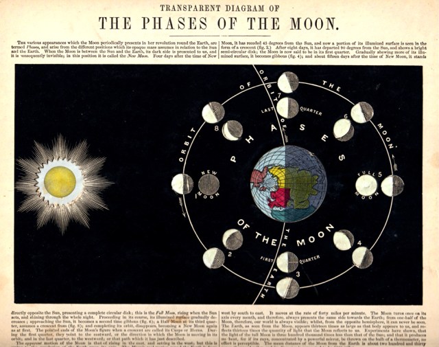
Twelve of the cards bear the additional information that they were drawn and engraved by John Emslie. One – a “Geographical Diagram of the Earth Adapted for Illustrating its Movements” has two volvelles (and who doesn’t love a volvelle?) – but, best of all, four of the diagrams (“Transparent Diagram of the Phases of the Moon”, “Transparent Chart of the Heavens”, “Transparent Solar System”, and “Comparative Magnitudes of the Planets”) are – as the titles imply – constructed with cut-outs and translucent papers, so that when the card is held to the light the image is brilliantly lit up to the pleasure and delight of the viewer. “Oh, wow! – That’s amazing” has been the most frequent response to everyone I’ve shown them to this week (which is just about everyone I’ve seen – everyone who’s come to the house, plus a few random passers-by).
As I had only just bought from a nearby stand a copy of Reynolds’ 1851 Great Exhibition map of London (engraved by the unfortunate Henry Martin, and with Emslie’s little map of the “Chief Objects of Interest in London” also included in the case), it was turning into something of a Reynolds day. He is someone that I have long felt has never been given his just due as an innovative and important publisher.  Born in Islington, his father was a printer, but Reynolds had set up for himself in the Strand by the 1830s and proceeded to produce a stream of instructive and educational material – standard maps and atlases, of course, but also thematic maps – astronomical maps, geological maps, zoological maps, botanical maps, tidal charts, physical maps, meteorological maps, ethnographic maps, geognostic profiles, and more. He was the first in the field in London on a number of these counts, and although he operated mainly at the cheaper end of the market, his work was always accurate and reliable. He routinely employed geographers as distinguished as Ernest George Ravenstein (1834-1913) and the geologist Professor John Morris (1810-1886) to advise on and construct his maps.

Advertisement for larger paper diagrams for schools. London Daily News, 9th July 1847 © British Library Board
The card diagrams in the folder illustrate everything that he was about – inexpensive but very attractive and fully up-to-date educational tools to be employed in the class-room and elsewhere. And he produced very large numbers of them. I have seen it said that the diagrams were sold in sets of twelve, but the present folder contains eighteen, while the last one I had contained just eight (including two transparent diagrams, one of the moon, and one of the stellar universe, not replicated here).  Some may have been mislaid over the years, of course, but I am fairly sure that the diagrams were originally sold individually and that you could go into his shop (frequently referred to as a print warehouse) and make an ad hoc selection for which a folder would be provided if you bought a sufficient number.
Reynolds and his family lived all his working life over the shop on the Strand and after his death, in 1876, the business was continued on into the twentieth century as “James Reynolds & Sons” by his sons William Henry Reynolds (1847-1907) and Frederick Reynolds (b.1850). His daughter, Alice Mary Reynolds (b.1852), also worked for the firm as a chromolithographic artist.

Stokes’s Capital Mnemonical Globe, 1868 © Barron Maps
Reynolds’ frequent collaborator over many years, John Emslie (1813-1875), was another native Londoner, born near the Elephant & Castle, and the son of a post-office clerk. Trained as an engraver, he is remembered for heraldic work and portraits, as well as his work on Ruskin’s “Modern Painters” (1856-1860), but increasingly over the years he came to specialise in maps and technical material, frequently as a skilled draughtsman as well as an engraver. He lived for most of his life on or near the Gray’s Inn Road and was followed into the business by his own two sons, John Philipps Emslie (1839-1913) and William Roland Emslie (1842-1918). A collection of almost 200 of his engravings was donated to the British Museum in 1913, but a personal favourite is the somewhat surreal “Stokes’s Capital Mnemonical Globe” of 1868, engraved by Emslie & Sons for William Stokes, “Teacher of Memory” at the Royal Polytechnic Institution on Regent Street, for more on whom see Rod Barron’s excellent website.
For some individual Reynolds charts and diagrams, as well as full details of the folder, see the Ash Rare Books website.

Susan Gabriele susangny@aol.com just found James Reynolds today & opened to a world never seen.
LikeLike