
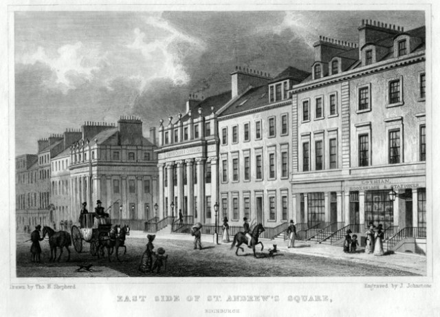
Always a delight to come across an old print depicting a bookshop, particularly if it can be readily identified. Here is a steel engraving of the “East Side of St. Andrew’s Square, Edinburgh”, engraved by James Johnstone of Edinburgh from an original study by the London artist Thomas Hosmer Shepherd (1793-1864). It was published in 1830 by Jones & Co. of London as one of a series of views of Edinburgh which appeared in monthly parts as “Modern Athens! Displayed in a Series of Views: or, Edinburgh in the Nineteenth Century” (1829-1831). I came across it last year (although I must certainly have come across it before and simply failed to register the bookshop) in Edinburgh itself – in a bookshop not far from the National Library of Scotland.
 It felt like a gift from the gods. The bookshop in the print was that of John Lothian (1802-1846) – a man about whom I was intending to speak at a forthcoming talk on the Scottish Map Trade to be given at the Library in a few weeks’ time. And Lothian was definitely someone I needed to know more of. I regret to say that we had neglected to give him an entry in “British Map Engravers : A Dictionary of Engravers, Lithographers and Their Principal Employers to 1850” – well, not neglected exactly – he was neither an engraver nor a lithographer, and “principal employer” may be stretching it a bit given his relatively short career – but he was also a globe-maker, or at least a globe-publisher, which should have given him an automatic right of entry as a special category. All of his maps and atlases are rare, but his globes excessively so – we simply didn’t know he produced any.

Pair of nine-inch globes by John Lothian. Edinburgh : 1828. © William Doyle Galleries, Inc. 2014.
I used the engraving to illustrate the talk, as well as this image of a pair of Lothian globes from the website of an American auction-house – still the only surviving Lothian globes of which I am aware. So far, so good – and, although not entirely straightforward, I had managed to put together the outlines of Lothian’s life and career.
He was born in Edinburgh on the 12th September 1802 and baptised at St. Cuthbert’s a week later – the son of Andrew Lothian and his wife Margaret Hogg. He set up as a bookseller at the age of twenty-two and was at these premises at 41 St. Andrew Square in the New Town from 1824 until 1831. He began as a general bookseller – mainly religion, with a bit of music and poetry – but soon came to specialise in cartographic material. By 1830 he was offering an “Historical Atlas of Scotland”, as well as a very prettily engraved and coloured Scottish county atlas; pocket-maps of the individual counties; a pocket bible-atlas; a large map of Edinburgh three feet across, with eighteen fine views; plans of most of the major Scottish towns; pocket road maps; recent maps of the wider world – and a range of globes – five-inch, seven-inch, nine-inch and twelve-inch.

© Daniel Crouch Rare Books
He was clearly by now in thrall to cartography. The preface to his county atlas insists that “Geography and Chronology have frequently been called the Eyes of History”, we all need our pathway to understanding “macadamized” by the use of maps – without a knowledge of them we will “derive as little benefit … from the facts we carry in our heads, as the ass does from the library he carries on his back”. This is all true and I hope you will all be attending the London Map Fair this weekend to make good any deficiencies you may have in that regard. And what is also known about Lothian is that he produced maps of both Edinburgh and Leith engraved by George Bartholomew (1784-1871) – the earliest signed maps from the founder of what was to become one of the greatest of all cartographic publishing houses.

The Scotsman, 7th January 1829. © British Library Board.
The reason that his premises are shown with such prominence in the print is simply that he was the Edinburgh agent for the publication of this series of views, working closely with the London publishers, but this set me to thinking of what an engraving like this does not show. What, in particular, this engraving does not show is what else was going on in this quiet south-east corner of what was originally a highly fashionable residential square – and, although Dundas House at No. 36 (set back from the other frontages and not visible in the print) became the headquarters of the Royal Bank of Scotland in 1825 – the square had not yet become Edinburgh’s major financial hub. It does not show who Lothian’s neighbours were and does not reveal that this small urban space had become something of a locus for the map trade. It does not show that the engraver and lithographer Alexander Forrester, who produced some of John Wood’s beautiful town-plans, was a neighbour at No. 30. It does not reveal that although the celebrated map and atlas-publisher John Thomson had by now moved to No. 32, he had been Lothian’s original next-door neighbour, in the years 1824-1826, at No. 40.
Thomson’s “New General Atlas”, completed in 1817, was quite the equal of anything being produced in London at the time and the first to mark Edinburgh as a potential rival to the capital in terms of map publishing. He then began work, from 1818 onwards, on his “Atlas of Scotland” – large maps of the Scottish counties made to the highest standard. Despite an initial 1,200 subscribers, it was, in Thomson’s words – “a work which he never would have undertaken, had he known the difficulties to be encountered”. Even before it was finished, he went bankrupt and had his estate sequestrated in April 1830. His creditors were compelled to settle up with the unpaid engravers to enable it to be completed. It finally appeared in 1832 – a stunning achievement – for the first time adequate mapping of the whole of Scotland was readily available – but Thomson’s final remaining assets were auctioned off in 1836 and he disappeared from view.

Post Office Annual Directory 1824-1825. © National Library of Scotland
Quite what Thomson thought of his young next-door neighbour carrying on a rival map-publishing business, is unknown (and Lothian may have been there first). But Lothian’s output essentially replicates Thomson’s – but at smaller scale – large folio atlases from Thomson – smaller and (in his words) more “economical and correct” versions from Lothian. I suppose it is not impossible that the two men viewed their businesses as complementary and that they were colleagues rather than rivals, but that could hardly be the case with some of the other neighbours. Thomson had moved to St. Andrew Square before the Great Fire of November 1824 in the Old Town compelled so many of his former neighbours to relocate in the same direction. Among them were the Kirkwood family, at this time represented by the elderly engraver James Kirkwood and his grandson Robert – the very first of those affected by the fire – it broke out in their own workshop when a pot of linseed oil (used in the preparation of plate-printing ink) caught fire. They moved more or less immediately to No. 3 South St. Andrew Street, running south off this corner of the Square, and only a few doors from Lothian and Thomson.

Edinburgh Evening Courant, 26th July 1828. © British Library Board
Earlier in the century, the Kirkwoods had become the makers of the first serious globes produced in Scotland – and that Lothian should have moved into globe production just at the time his new neighbours were trying to rebuild the business (their plates had been lost in the fire) can hardly have been viewed as a friendly act. In the event, Robert Kirkwood seems to have won the globe-wars. It appears to have taken him until 1828 to resume globe-production but by 1832 he was selling his twelve-inch globes for virtually the same price as Lothian’s nine-inch ones – and Lothian moved out of the square. Forrester had already left and then – in 1835 – so did Kirkwood. John Thomson was the last to leave in 1836 – but just as these major map-businesses depart, who should arrive? The brothers William and Alexander Keith Johnston (W. & A. K. Johnston), destined for a time to sweep all before them in British mapmaking, moved into No. 4 on the south side – just yards from the Lothian shop. They had been trained by the Kirkwoods and had worked for Thomson, but bought up Thomson’s bankruptcy stock of maps and plates when they were auctioned off – and before long usurped the Kirkwoods in the matter of globes. They were to remain in St. Andrew Square for the next thirty years.
As for John Lothian, he next appears living with his brothers, Alexander and Andrew (both lawyers) at 37 George Square to the south of the city (not George Street, in the New Town, as is sometimes claimed). In 1834 he completed both “A New and Elegant Classical Atlas” and his “New General Atlas” – an atlas “neither to be swelled in price or bulk by letter-press, nor by unnecessarily subdividing countries and multiplying maps” – both published in monthly parts and the latter at least apparently printed for him by W. & A. K. Johnston. He then moved, still with his brother Alexander, to 21 Atholl Crescent (1836-1838), and subsequently to 2 Baxter’s Place (1840-1843). At this latter address, where, incidentally, Robert Stevenson (1772-1850), the celebrated light-house engineer, was their next-door neighbour, he began to style himself as “geographer” rather than “map publisher”.

Edinburgh Directory 1841.
A final move for John Lothian and his brother was to 3 Abercromby Place (1844-1846), the house (again incidentally) where Marie Stopes was born in 1880. Alexander Lothian’s estate was sequestrated for debt in 1842 – the papers describing him as both advocate and publisher – so presumably he was involved in John Lothian’s residual publishing activities, but beyond winning the Silver Medal of the Edinburgh Society of Arts in 1837 for the invention of a device for bottling liquors, and compiling a “Table to Find the Number of Days Between Two Dates”, marketed as “Lothian’s Time Reckoner” and published by James Brydone in 1839, quite what John Lothian was doing in these years is a little unclear. But in 1841-1842 he and his brother had been sharing the Baxter’s Place premises with Thomas Brumby Johnston (1814-1897), the younger brother of William and Alexander Keith Johnston, later to become a partner and the future head of the firm – which perhaps suggests that by now Lothian was himself working with or for the Johnstons.
According to Moir’s “Early Maps of Scotland”, John Lothian died on 11th May 1846, his personal estate (valued at £95) consisting of a three-quarter share of copyrights, copper-plates and sheets on hand of his maps and atlases. I suspect that the final two publications to bear his name, “The People’s Atlas” and the “New Edinburgh General Atlas”, both published by others in 1846, were made up from these surviving plates and sheets. A later edition of the latter was published by his Edinburgh contemporary John Gellatly and the plates for his county maps seem to have been acquired by Adam & Charles Black. A relatively short life – just forty-three when he died – and a correspondingly short career – but by no means an insignificant one.
